Route ideas
Bogotá, Medellín, Coffee Region, Cartagena: 14-day Colombia itinerary
Distances in Colombia are longer than they appear on the map because there are three Andean ranges in between. What determines the route is not the mileage, but the domestic flight network.
FlyVentis editör ekibi tarafından hazırlanmış, seyahat ve etkinlik bilgileri düzenli olarak gözden geçirilen rehber.
First rule of routing in Colombia: don't trust the map. The country is divided by three separate branches of the Andes Mountains, and if the distance between two cities is 300 kilometers, this can mean 9 hours by road. On the other hand, the domestic flight network is very busy and cheap if booked early; It is almost mandatory to base the route on flights.
The second rule is altitude. Bogotá is at 2,640 meters, Cartagena is at sea level, and the difference between the two changes everything from breath to climate. This route is based on 14 days and goes from high to low.
Day distribution: how many nights where?
| Stop | Altitude | Night | Why so much? |
|---|---|---|---|
| Bogota | 2,640 m | 3 | Center, museums and Zipaquirá; harmony day |
| Medellín | 1,495m | 3 | City transformation and Guatapé day trip |
| Salento (Coffee Region) | 1,900m | 3 | Vineyards, farms and Cocora walk |
| Cartagena | 0m | 3 | Walls, old city and islands |
| Santa Marta / Tayrona | 0m | 2 | National park and return |
Bogotá and surroundings
- Bogota La Candelaria is the colonial center of the capital: a mix of colorfully painted one-storey houses, narrow stone streets and street art covering the walls. The neighborhood can be explored on foot, and guided street art tours are a real asset here, as many of the walls have a political story.
- The Gold Museum (Museo del Oro) is in the same neighborhood and contains more than 55 thousand pre-Columbian gold artifacts; The world's largest collection in this field. Take two hours, the halls are arranged according to cultures, not chronologically.
- Monserrate hill is above the city at 3,150 meters; You can go up by funicular or cable car, and you can only understand how large Bogotá is from above. There is a higher chance of clear clouds in the morning.
- Salt Cathedral of Zipaquirá 1 hour from Bogotá: cathedral carved 180 meters below an abandoned salt mine. There are 14 stations along the tunnel and a giant hall at the end; the lighting changes color on the salt walls. Half a day is enough, it's cool inside.
Medellín and the Coffee Region
- Medellin Comuna 13 is the country's most talked about transformation story: the hillside, once the city's most dangerous neighborhood, is now a visited area with its open-air escalators and murals. Going with a local guide means both accurate information and accurate time; The neighborhood is not an ordinary tourist stop, it is a place where people still live.
- Medellín metro is the pride of the city and metrocables are part of public transport; Going up one of the lines leading to the hillside neighborhoods is a journey that shows both the city view and social transformation. You can get on with a metro card.
- Guatape Rock 2 hours from Medellín: a single piece of granite rock rising 200 meters from the plain and 740 steps to the top. The indented structure of the dam lake extending below is visible from above. The adjacent town of Guatapé is a separate stop with its colorful reliefs decorating the lower parts of the houses.
- Cocora Valley 30 minutes from Salento: wax palms, the world's tallest palm, reach 60 meters and rise from a cloudy valley floor. The circular walking route is 5 hours, the short version is 2 hours; The road is muddy, rubber boots are rented.
- Coffee Cultural Landscape the entire region is on the UNESCO list; Farm tours show the entire process from coffee picking to roasting, and most farms also offer accommodation. Staying at the farm overnight is a much better experience than a day tour.
caribbean coast
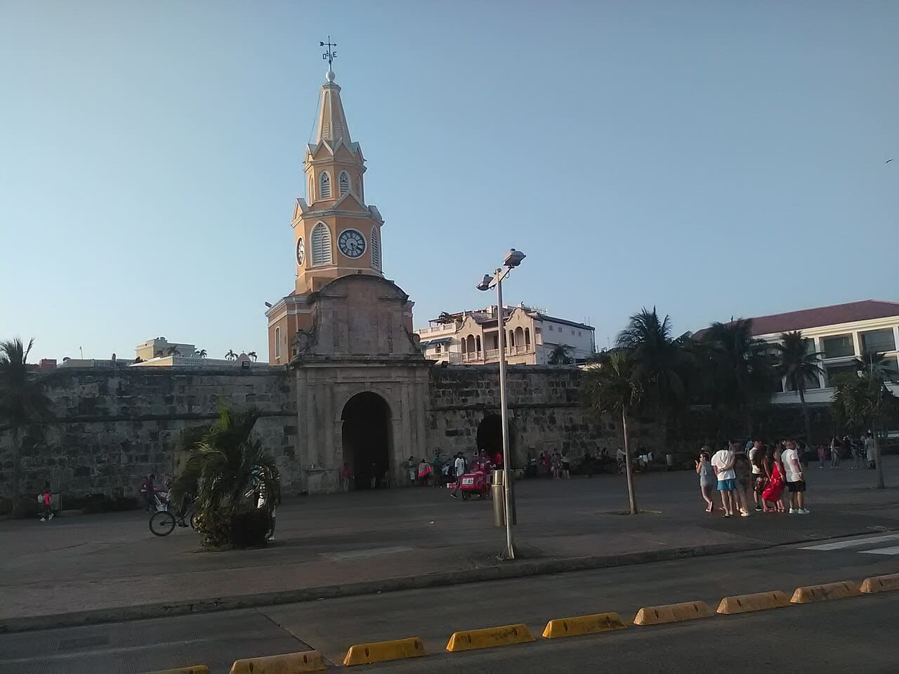
- Cartagena Old Town Colonial city surrounded by 13 kilometers of city walls; Colorful houses with begonias hanging from their balconies and walking on the city walls in the evening are the most atmospheric part of the route. Temperatures and humidity are high during the day, so explore the city early in the morning and after sunset.
- Rosario Islands 1 hour by boat from Cartagena: a set of small islands surrounded by coral reefs. Day tours can be crowded, staying one night on one of the islands is much calmer.
- Tayrona National Park 1 hour from Santa Marta: national park where the rainforest leads directly to the Caribbean beaches. There is a quota for entry into the park and in some periods it is completely closed for ecological recreation, so check the dates in advance. The walk from the entrance to the beaches is 1.5-2 hours and the humidity is high.
- San Agustin Archaeological Park for those who will extend the route south: the largest burial site of the pre-Columbian period with its stone sculptures, on the UNESCO list. It is difficult to reach and requires a separate leg.
Transport, safety and practical notes
| Connection | Flight | Highway |
|---|---|---|
| Bogotá → Medellín | 1 hour | 9 hours |
| Medellín → Pereira (Coffee Region) | 45 minutes | 6 hours |
| Pereira → Cartagena | 1 hour 30 minutes | 16 hours |
| Cartagena → Santa Marta | - | 4 hours |
- Domestic tickets are very cheap if purchased early; For economy fares with low hand luggage allowance, add the baggage fee upfront, it is expensive to buy it later.
- In cities, calling a taxi via an app is both safer and cheaper than hailing from the street; Limit night walking to main streets.
- It has become a local saying not to carry valuables visibly: do not hold the phone in your hand in crowds.
- The currency is peso and the number of zeros is high; Double check the number when paying. Payment by card is common in cities, cash is required in rural areas.
- Yellow fever vaccination is recommended for those traveling to regions such as Tayrona and the Amazon; Vaccination certificate may be requested when traveling to some countries.
| Pen | Economic | Middle | Comfortable |
|---|---|---|---|
| Domestic flights (3 legs) | $120-200 | $200-$320 | $320-$500 |
| Accommodation (13 nights) | $260-$450 | $450-850 | $850-1,800 |
| Food and beverage | $180-290 | $290-450 | $450-750 |
| Tour and entrances | $120-200 | $200-$320 | $320-$520 |
| urban transportation | $60-100 | $100-170 | $170-280 |
| Total | $740-$1,240 | $1,240-$2,110 | $2,110-$3,850 |
When to go?
December-March and July-August are the dry seasons; These are the best periods for the Coffee Region and Tayrona. Since Colombia is close to the equator, the altitude is the determining factor, not the season: Bogotá has a temperature of 14-19 degrees throughout the year, Cartagena has a temperature of 28-32 degrees throughout the year. Rainfall peaks in April-May and October-November; The rain usually happens for short periods of time in the afternoon, but it makes hiking routes like Cocora muddy. The carnival of Cartagena in January and Barranquilla in February fills the region completely.
Keep planning
Frequently asked questions
How many days does it take to visit Colombia?
10 days is enough for Bogotá, Medellín and Cartagena. When you add the Coffee Region and Tayrona, 14 days gives a comfortable pace; Since road distances are long, domestic flights are necessary.
Do I have to fly intercity?
In practice yes. Bogotá-Medellín takes 9 hours by road, Pereira-Cartagena 16 hours; same legs 1-1.5 hours by flight. Domestic tickets purchased early are at a price competitive with bus tickets.
Is altitude a problem?
Bogotá is at 2,640 meters and a slight headache and easy fatigue are normal in the first 24 hours. Setting the route from high to low naturally solves this harmony; Keep the arrival day light.
Is Tayrona National Park always open?
No. The park is completely closed several times a year for ecological recreation and entrances are subject to quotas. Check the dates before travelling, falling into a closed period will void the last leg of the route.