Route ideas
Buenos Aires, Patagonia, Santiago: 16-day Argentina - Chile route
Argentina and Chile are next to each other on the map, but between them are the Andes Mountains. What determines the route is not the distance, but which flight is open in which season.
FlyVentis editör ekibi tarafından hazırlanmış, seyahat ve etkinlik bilgileri düzenli olarak gözden geçirilen rehber.
Argentina and Chile share a long border on the map, but there are Andes between them. Therefore, transit between two countries depends on which airport provides connection in which season, not on the distance. It is necessary to establish the route according to the flight schedule, not from north to south.
This route is based on 16 days: You start in Buenos Aires, turn towards the waterfalls in the north, go down to Patagonia, cross the Andes, go to the Chilean side and return from Santiago. Since we are in the southern hemisphere, the seasons are reversed: December-February means summer.
Day distribution: how many nights where?
| Stop | Country | Night | Why so much? |
|---|---|---|---|
| Buenos Aires | Argentina | 4 | Neighborhoods are far from each other; Tango and Sunday are separate |
| Puerto Iguazu | Argentina | 2 | Waterfalls are seen by both countries |
| El Calafate | Argentina | 3 | A glacier day, a boat tour day, a spare day |
| Torres del Paine | chile | 3 | At least two full days inside the park are required |
| Santiago / Valparaíso | chile | 4 | City two days, coast and vineyards two days |
Four days in Buenos Aires
Buenos Aires neighborhoods are very different from each other and the distances between them are not walkable. It is necessary to divide the days according to the neighborhood; The metro is cheap and fast, but it closes early in the evening.
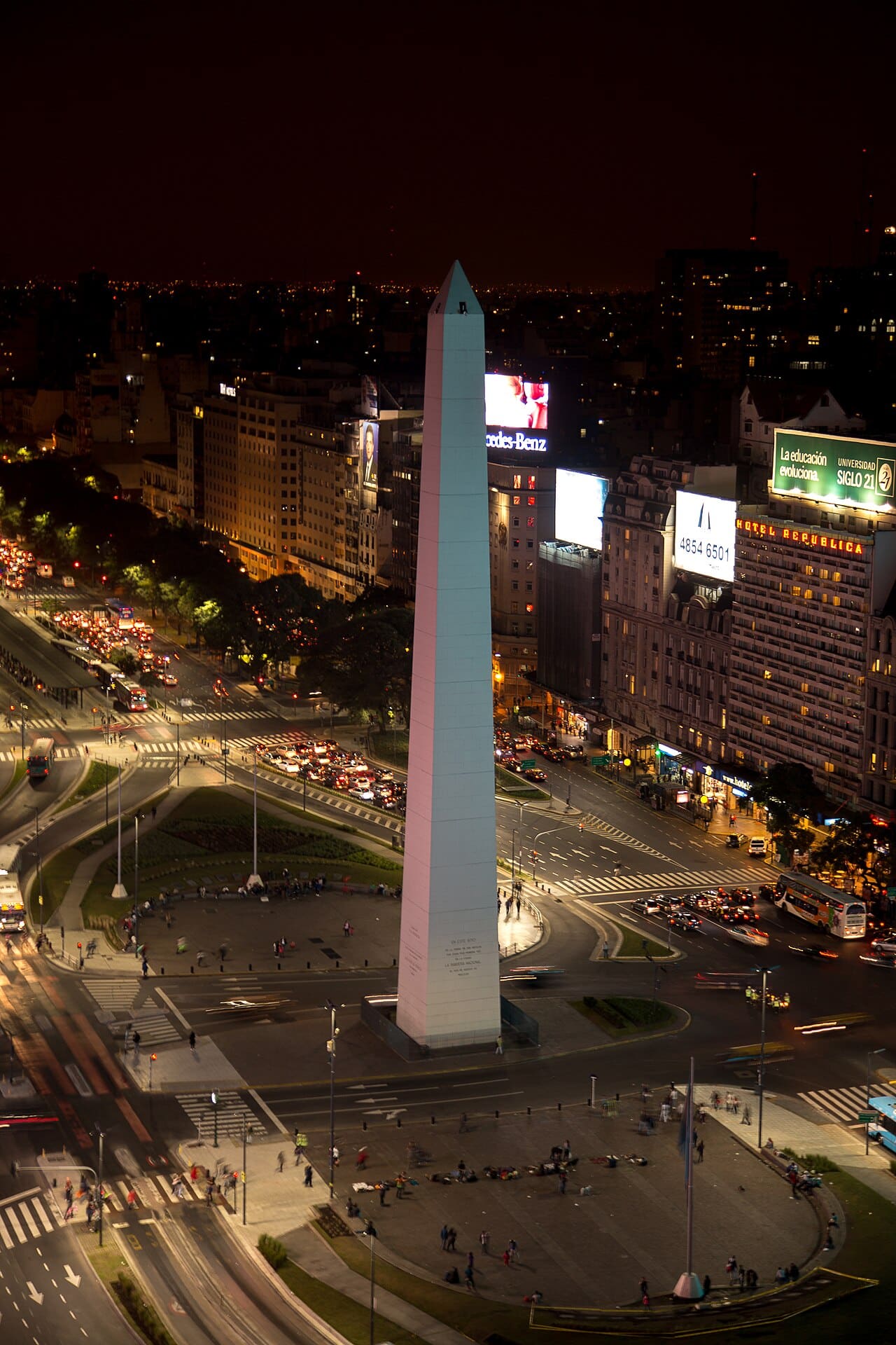
- Obelisco: It is a 67-meter monument in the center of the city and stands in the middle of 9 de Julio, which is considered the widest boulevard in the world. A short stop in itself, but the right starting point to grasp the scale of the city; From here, Teatro Colón and the historical center are within walking distance.
- Caminito: Street known for its colorful iron houses in the La Boca neighborhood; It is a tradition that arose from Italian immigrants working in the port painting their houses with ship paint residues. The street is touristy and prices are high, but the tango shows and artist workshops are real. Go during the day; The area around the neighborhood is not safe in the evening hours.
- Recoleta Cemetery: a small city rather than a cemetery; Four thousand marble mausoleums line the narrow streets, including Eva Perón's. The difference between the entrance fee and the guided tour is huge, because without the story of the tombs, only the architecture remains. Allow two hours.
- Tigre Delta: delta north of the city, where the Paraná River divides into thousands of islands; 1 hour by train, then by boat. There is no highway on the islands, everything works over water. The perfect day trip to get out of the concrete density of Buenos Aires.
Waterfalls and glaciers
- Iguazú Falls: A two and a half kilometer wide waterfall system consisting of 275 separate cascades. The Argentinian side takes you into the waterfalls with walking platforms, and you stand right above the point where the water falls in the Devil's Gorge; The Brazilian side gives the panoramic angle. It's best to see both, reserve a full day for the Argentinian side and bring a raincoat, it's impossible not to get wet.
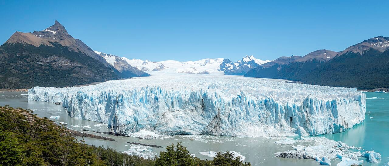
- Perito Moreno Glacier: one of the few still advancing glaciers in the world; An ice front 5 kilometers wide and 60 meters high pours into the lake. The falling of ice masses breaking off from the front repeats throughout the day and the sound can be heard several kilometers away. 80 kilometers from El Calafate; You spend a few hours on the platform system and a full day on the ice walking tour.
- Ushuaia: the southernmost city in the world, on the island of Tierra del Fuego; It is also the departure port of Antarctic expeditions. The Beagle Channel boat tour stops by sea lion and seabird colonies. It is necessary to add two days to the route, but the flight to El Calafate is 1 hour and 20 minutes.
- Torres del Paine: Main park of Chilean Patagonia; South America's best-known hiking destination, with its three granite towers, glacial lakes and herds of guanaco. The single-day route to the towers takes 9-10 hours and the last part is steep rock climbing. Refugio and campsites within the park fill up months in advance; Those who come without a reservation cannot find a place to spend the night in the park.
Chilean side: Santiago, coast and vineyards
Santiago is located at the foot of the Andes; snowy peaks visible from the city center on a clear day. The city itself requires two days, while the surrounding coastal and vineyard regions require two separate days.
- Sky Costanera Santiago: The observation deck of the tallest building in South America at 300 meters; In clear weather, the entire Andes appear as a panorama. Views are often blocked in the city due to pollution, so it makes more sense to go when the weather is clear rather than buying the ticket in advance.
- Valparaíso: hillside port city; It is on the UNESCO list with its colorful houses, street art and 19th-century funicular system. The hills are steep, some of the funiculars are still working and take you from one neighborhood to another for a few hundred pesos. 1.5 hours from Santiago; Staying one night allows you to see the evening light.
- Casablanca Valley: Cool-climate vineyard region between Santiago and Valparaíso; Center of sauvignon blanc and chardonnay production. Most vineyards accept visits by appointment, you must write in advance rather than driving on your own.
- Cajón del Maipo: Mountain valley 1 hour from Santiago; The fastest option to get out of the city with its thermal springs, walking routes and glacial lake. The road is narrow and winding, and traffic is heavy on weekends.
- Atacama Desert: the driest desert in the world if you can add four days to the route; It offers a completely different view with geyser fields, salt lakes and sky observation tours. 2 hours by flight from Santiago, altitude 2,400 meters.
Transportation and border crossing
The distances on this route are unthinkable on a European scale: The distance between Buenos Aires and El Calafate is 2,700 kilometers, that is, the distance between Istanbul and London. Almost all transportation between blocks is done by flight.
| Connection | Duration | early purchase | breaking news |
|---|---|---|---|
| Buenos Aires → Puerto Iguazú | 1 hour 50 minutes | $60-110 | $180-280 |
| Buenos Aires → El Calafate | 3 hours 20 minutes | $90-160 | $250-400 |
| El Calafate → Puerto Natales (land) | 5 hours bus | $25-40 | - |
| Punta Arenas → Santiago | 3 hours 30 minutes | $80-140 | $220-$350 |
- Agricultural control on the land border between Argentina and Chile is tight; Fresh fruits, vegetables, meat and dairy products are not allowed and fines are imposed for undeclared products.
- The transition from El Calafate to Torres del Paine is done by bus. At the border, all passengers get off and queue for passport processing; The journey takes 5-7 hours.
- For domestic flights in Argentina, foreign passenger pricing and domestic pricing may differ; Buying the ticket from the country's official airline website is generally the most transparent way.
- Flights in Patagonia are frequently delayed due to wind; Allow at least 3 hours between connecting flights.
| Pen | Economic | Middle | Comfortable |
|---|---|---|---|
| Domestic flights (4 legs) | $350-550 | $550-850 | $850-$1,400 |
| Accommodation (15 nights) | $450-750 | $750-$1,400 | $1,400-$2,800 |
| Food and beverage | $300-450 | $450-700 | $700-$1,200 |
| Park entrances and tours | $250-400 | $400-650 | $650-$1,100 |
| Local transport and buses | $120-200 | $200-$320 | $320-$500 |
| Total | $1,470-$2,350 | $2,350-$3,920 | $3,920-$7,000 |
When to go?
The only realistic window is between November and March; Patagonia is clear during these months and daylight finds it in the evening. December-February is the most crowded and expensive period, and in-park accommodations fill up months in advance. November and March give the best balance: routes are open, prices are lower, crowds are less. After April, Patagonia begins to close; If you are going during that period, base the route on Buenos Aires, Iguazú, Mendoza and Santiago.
Keep planning
Frequently asked questions
How many days does it take to visit Argentina and Chile?
16 days is the lower limit for visiting two countries including Patagonia. If you want to squeeze it into 10-12 days, leave out Iguazú and settle for the trio of Buenos Aires, El Calafate and Santiago.
In what season to go to Patagonia?
Between November and March. During this period, which is summer in the southern hemisphere, hiking routes, in-park accommodation and domestic flights are open. Many facilities and routes close between April and September.
How to transit between two countries?
In Patagonia, the land border between El Calafate and Puerto Natales is used by bus, the journey is 5-7 hours. In the north, the flight from Buenos Aires to Santiago is 2 hours. The passage of fresh food is prohibited at the land border.
Is reservation required for Torres del Paine?
If you are going to spend the night in the park, yes. Refugio and campsites fill up months in advance and accommodation without reservation is not allowed. A park ticket is sufficient for daily entry.